
NEW DELHI: The India Meteorological Department (IMD) on Thursday said that Cyclone Biparjoy is moving north-northeastwards towards Saurashtra and Kutch coast and is around 180 km away from Jakhau port.
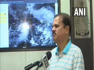
Director General of the India Meteorological Department, Mrityunjay Mohapatra, gave an update on the movement of Cyclone Biparjoy in the Arabian Sea.
“This morning, Cyclone Biparjoy is moving north-northeastwards towards Saurashtra and Kutch coast and is around 180 km away from Jakhau port. It is currently centred on the northeast Arabian Sea. The wind speed is 125-135 kmph gusting to 150 kmph. By evening, it will reach the coast and hit the Saurashtra-Kutch coast near Jakhau port and the Pakistan coast. The predicted wind speed is 115-125 kmph gusting to 140 kmph, a Very Severe Cyclonic Storm”, said the IMD Director General.
He also explained that the cyclone had weakened from an Extremely Severe Cyclonic Storm to a Very Severe Cyclonic Storm in line with the predictions, and the wind speeds had reduced marginally at the cyclone’s centre. However, he reiterated that Biparjoy is a severe storm.


Ahead of Cyclone Biparjoy’s landfall, India Meteorological Department (IMD) on Thursday said that the Very Severe Cyclonic Storm (VSCS) can cause severe damage to small structures like thatched houses and uproot trees. High tidal waves and heavy rainfalls are also expected in the coastal districts of Gujarat.
Warning the public about the effects of Cyclone Biparjoy, he said, “The cyclone brings damaging potential; trees and branches can fall, and small structures like thatched houses, slums, mud houses, tin houses or houses with asbestos can suffer severe damage. Along with this, tidal waves and heavy rainfalls are also likely in the coastal districts”.
He explained that coastal districts like Porbandar and Dwarka will see high wind speeds, Very Heavy to Extremely Heavy rainfall, and high tides would be seen on the Gujarat coasts. “Tidal waves as high as 2-3 mt are extremely likely on the Kutch coast”, he added.
On Wednesday, the IMD issued a red alert for the Saurashtra and Katch coasts of Gujarat, warning the people about extreme weather conditions expected in the concerned districts.
“VSCS Biparjoy over Northeast Arabian Sea at 0530 hours IST of 15th June, 2023 about 180km west-southwest of Jakhau Port (Gujarat). To cross Saurashtra & Kutch and adjoining Pakistan coasts between Mandvi and Karachi near Jakhau Port by evening of 15th June as a VSVS”, tweeted IMD.
#WATCH | "Teams are taking stock of the low-lying areas. Relief work is underway. Its (Cyclone Biparjoy) effect will be maximum till 4-8 pm," says Anupam, Deputy Commandant, NDRF, Gandhinagar pic.twitter.com/3M4zd4rQIQ
— ANI (@ANI) June 15, 2023
In addition to this, ahead of the cyclone, National Disaster Response Force (NDRF) and State Disaster Response Force (SDRF) were deployed in Gujarat on Wednesday. The teams are working in order to safely evacuate people and animals out of low-lying coastal areas and to prepare other protective measures for the incoming storm.
“The NDRF and SDRF have been deployed in Kachchh’s Mandvi and Naliya town which is likely to be affected as Cyclone Biparjoy is getting closer”, said Naliya Police Sub-Inspector VR Ulva.
The Indian Army is also prepared to provide relief and resources to the affected areas and people. According to Wing Commander N Manish, the Defence PRO & Spokesperson MoD for Gujarat, the Army, Navy, Air Force and the Indian Coast Guard are all prepared to assist the locals of Gujarat affected by the cyclone.
“Indian army has deployed more than 27 relief columns across Gujarat as well as at the forward locations of Mandvi, and Dwarka. Army authorities have also jointly started relief operations along with civil administration as well as with the NDRF teams”, he said. (ANI)